VIS-NIR-SWIR Analysis
The reflectance data in the Vis-NIR-SWIR range were obtained with the FieldSpec 3 (Analytical Spectral Devices, ASD, Boulder, CO) spectroradiometer, which operates within the spectral range from 350 to 2,500 nm. The spectral resolution varied for each range: 3 nm, from 350 to 700 nm; 10 nm, from 700 to 2,500 nm. The output data are automatically interpolated to 1 nm, resulting in 2,151 channels (or bands).
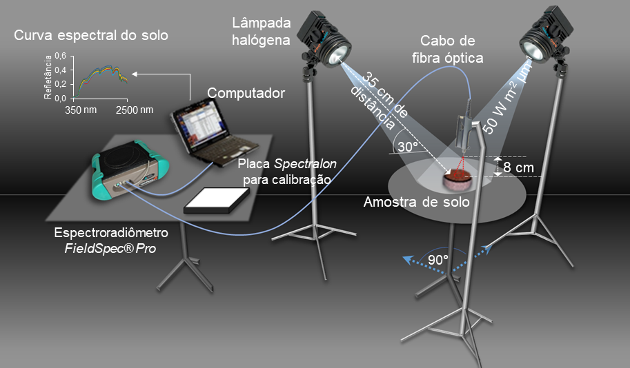
The soil samples were dried in an oven at 45° C for 48 hours and ground and sieved in 2 mm mesh. Then, they were disposed in Petri dishes with 9 cm of diameter by 1.5 cm of height. The surface of the samples was homogenized (should be flat, without any undulation), reducing the influence of roughness (shading). The spectral reading was performed in a dark room, to avoid light interference, using an optical fiber connected to the sensor. The sensor used captures light through a fiber optic cable allocated in a vertical position with a distance of 8 cm from the sample surface, which reflects the light coming from two 50W halogen lamps. These lamps were positioned at an angle of 90° to each other and 35 cm from the sample with a 30° zenith angle, as shown in the following figure:

Before starting the readings, the sensor was calibrated using a white Spectralon plate, representing a 100% reflectance pattern. For each sample, three readings were taken in different positions, rotating the plate by 90°, where each reading resulted from an average of 100 scans taken by the sensor. From these three readings, the final spectrum of each sample was calculated. In future spectroscopic analyses it is suggested to use the protocol indicated by Ben-Dor et al.,2015.
References:
Ben-Dor, E., Ong, C., & Lau, I. C. (2015). Reflectance measurements of soils in the laboratory: Standards and protocols. Geoderma, 245, 112-124.
Poppiel, R. R., Lacerda, M. P., Demattê, J. A.M., Oliveira Jr, M. P., Gallo, B. C., Safanelli, J. L. (2019). Pedology and soil class mapping from proximal and remote sensed data. Geoderma, 348, 189-206.

 pt-br
pt-br en
en